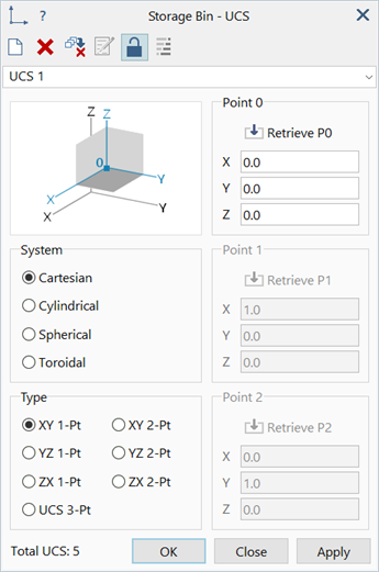
Global: Define Cartesian UCS
Description
Defines a Cartesian coordinate system (UCS) (see Global: Define UCS).
Cartesian coordinate systems use the coordinates X, Y and Z to define the position of a point.
Dialog
Type
Method used to position and orientate the Cartesian UCS.
-
XY / YZ / ZX 1-Pt
A single point (Point 0) defines a Cartesian UCS on one of the global Cartesian planes (XY-plane, YZ-plane or ZX-plane).
The origin is located at Point 0.
The Z axis is perpendicular to the selected plane.
The X axis is parallel to the first axis on the selected plane (i.e., the global X, Y or Z axis for the XY, YZ and ZX planes, respectively).
The Y axis is parallel to the second axis on the selected plane (i.e., the global Y, Z or X axis for the XY, YZ and ZX planes, respectively).
Point 1 and Point 2 are implicitly defined.
-
XY / YZ / ZX 2-Pt
Two points (Point 0 and Point 1) define a Cartesian UCS on one of the global Cartesian planes (XY-plane, YZ-plane or ZX-plane).
The origin is located at Point 0.
The Z axis is perpendicular to the selected plane.
The X axis lies on the plane and is generally directed from Point 0 to Point 1.
The Y axis is perpendicular to both the Z and X axes, and is calculated as the vector cross product Z × X.
Point 2 is implicitly defined.
-
UCS 3-Pt
Three points (Point 0, Point 1 and Point 2) define an arbitrarily orientated Cartesian UCS.
The origin is located at Point 0.
The X axis is directed from Point 0 to Point 1.
The Y axis lies on the plane defined by the three points, is perpendicular to the X axis, and is generally directed towards Point 2.
The Z axis is perpendicular to both the X and Y axes, and is calculated as the vector cross product X × Y.
Point 0 / Point 1 / Point 2
Three points used to position and orientate a Cartesian UCS.
Coordinates of points may be retrieved from the model by clicking a node, vertex or grid point, or by explicitly typing the values into the edit boxes.
See Also